TeleCAD - GIS
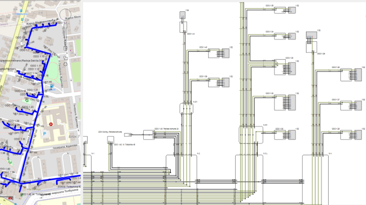
TeleCAD-GIS is our flagship product, and at the same time the most comprehensive tool. It is intended for planning, design and maintenance of telecommunications networks and for the preparation of technical documentation in digital or printed form.
Whom is it for?
- TeleCAD-GIS standalone desktop application users. These include: Telecom operators, design bureaus, engeneers and technitians
- INOVA GIS Platform users (enterprise GIS): Telecom operators, Power grid operators (for networks with OPGW cables).
TeleCAD-GIS users are generally divided into two groups:
- Fiber optic networks including: transport network, FTTx networks, networks using OPGW cables (power-line optics)
- Copper networks
- HFC networks
- Conduit networks
Scope of application

TeleCAD-GIS characteristics
Design with ease
Automatically convert geodetic survey or any CAD drawings into routes. Obtain geometry using GPS device and import it directly as TeleCAD-GIS objects. Harvest the power of shortest path algorithm to quickly lay down cables and ducts. Use predefined symbols of nodal network elements. Define properties of your network elements using predefined extensible catalogues.
Get a clear insight
Use unparalleled automatically generated schematic diagrams of cables and fibers to work on your network.See every fiber's connections, trail, attributes... Filter fibers. Splice fibers in splice cases and terminate them on connectors of terminal network elements right there on the schematic diagram. Splice and connect fibers within detailed schematic diagram of every splice case, ODF, OTB, FTB etc.Just drag and drop fibers and you're done.
Add data to your fibers: fiber name, owner, lease data, OTDR data...

Manage hierarchical structure
Use FO network tree tool to revise connectivity of finished network. See if the elements are connected to the main supply source and check if they are connected in an intended way.
Or,
use FO network tree to quickly define hierarhical structure of newly designed network. Add spare fibers (reserves) throughout the network and automatically designate the position of every element on a ODF and within main cable. Than, automatically optimize cables capacities and splice entire network by just one click.

Microducts
Microducts module enables automatic microducts laying, automatic FO cables optimization and automatic splicing. Blowing microcables into ducts is reduced to just one click.
Reports and analytical tools provide inspection at any given point in time.
Keep in mind that manual splicing and field changes, especially in exploitation phase, can be performed at any time on any network element.

OTDR Trace
Locate an outage based on OTDR measurements.
Simply insert an optical length and TeleCAD-GIS will pinpoint an outage location on the map.
Slackloops, cable lengths and terrain are all taken into account to get accurate optical distances.
Calculate attenuations and power budget for selected optical fiber. Find available path between any two or more elements of your FO network. If there is no direct fiber connection program shall propose actions (splicing, patching etc. within nodal elements) in order to create desired path. Use this to find alternative path while an outage is dealt with.

TCG Assistant
It is an Android based mobile application for keeping track of telecommunications infrstrucure objects.
Read more

INOVA PEU
INOVA PEU is a software application for calculating the impact of electric power cables or electric traction plants on telecommunication cables.
Read more

Object model for Trimble GPS devices
It enables points and routes to be presented in the form of TeleCAD-GIS during the very act of recording telecommunication facilities with associated features.
Read more

Your ideas
INOVA solutions start with great ideas. Tell us yours. Contact us by email or phone.


